Tropical cyclone structural changes in recent decades
TC structure varies in the changing climate. My work focuses on this question: how does the TC inner-core structure vary under the climate change?
Weaker inner-core convection
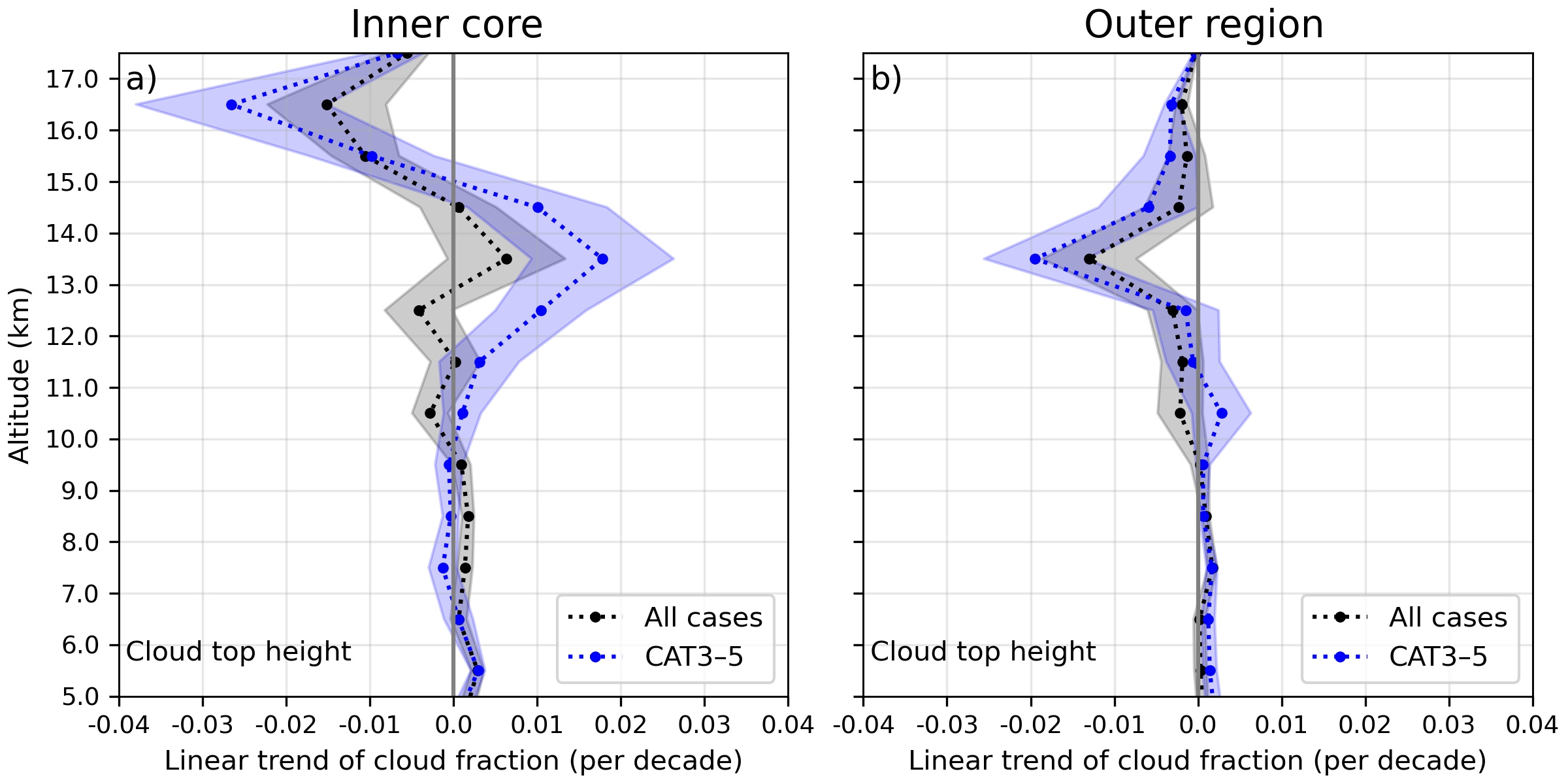
Satellite observations of TC clouds indicate that the inner-core convection becomes weaker in the recent decades. Specifically, cloud fraction of tropical cyclone (TC) high thick clouds has recently declined in the inner core while the change in the outer region is much smaller (the above figure). The decline was most significant during the intensification period. The percentage change of TC inner-core cloud fraction of high cloud was similar to that of TC inner-core rain rate. The declining amount of inner-core high thick clouds and the decreasing inner-core rain rate suggest that the TC inner-core convection has become weaker. See Lai and Toumi (2023) for more details.
Tropical cyclone eyewall replacement cycles
Multiple-eyewall structure is a frequently observed feature of intense TCs; and the most common form is double-eyewall. This process is about the formation of an outer (secondary) eyewall which takes place outside the existing (primary) eyewall. The strengthening outer eyewall then generally replaces the weakening and dissipating inner eyewall. It is not rare that an intense TC performs more than one eyewall replacement during its lifetime. In particular, the project explored the underlying processes related to inner eyewall decay and outer eyewall intensification.
ERCs and the dynamical instability between the two eyewalls
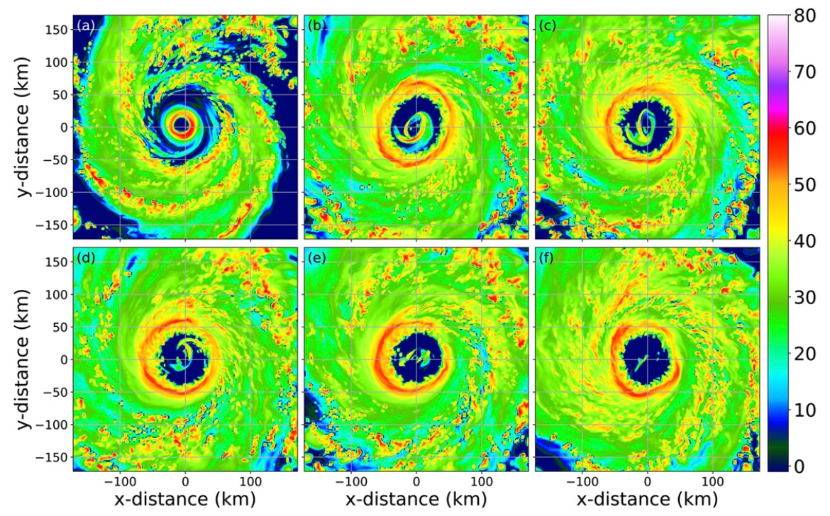
The region of convective minimum and vorticity minimum between the two eyewalls is referred to as a moat. This local vorticity minimum makes the vortex susceptible to the barotropic instability across the moat (a.k.a. the type-2 instability). The figure on the left (from Lai et al. 2019) shows an azimuthal wavenumber-2 (elliptic) evolution associated with the type-2 instability in the simulated Hurricane Wilma (2005) of which the inner eyewall became elliptic before the decay.
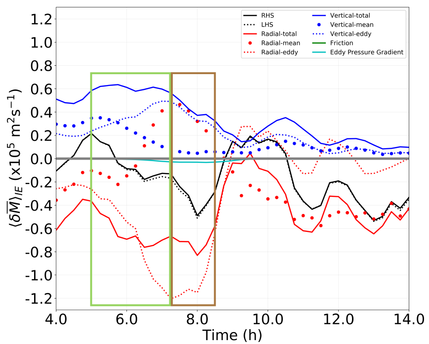
Detailed budget analyses of absolute angular momentum [e.g. the figure on the left] revealed that the radial eddy transport of absolute angular momentum associated with the vorticity mixing of the type-2 instability can significantly weaken the inner eyewall. This effect of the type-2 instability can also work synergistically with the cut-off effect. See Lai, Hendricks, Menelaou, and Yau (2021) for more details.
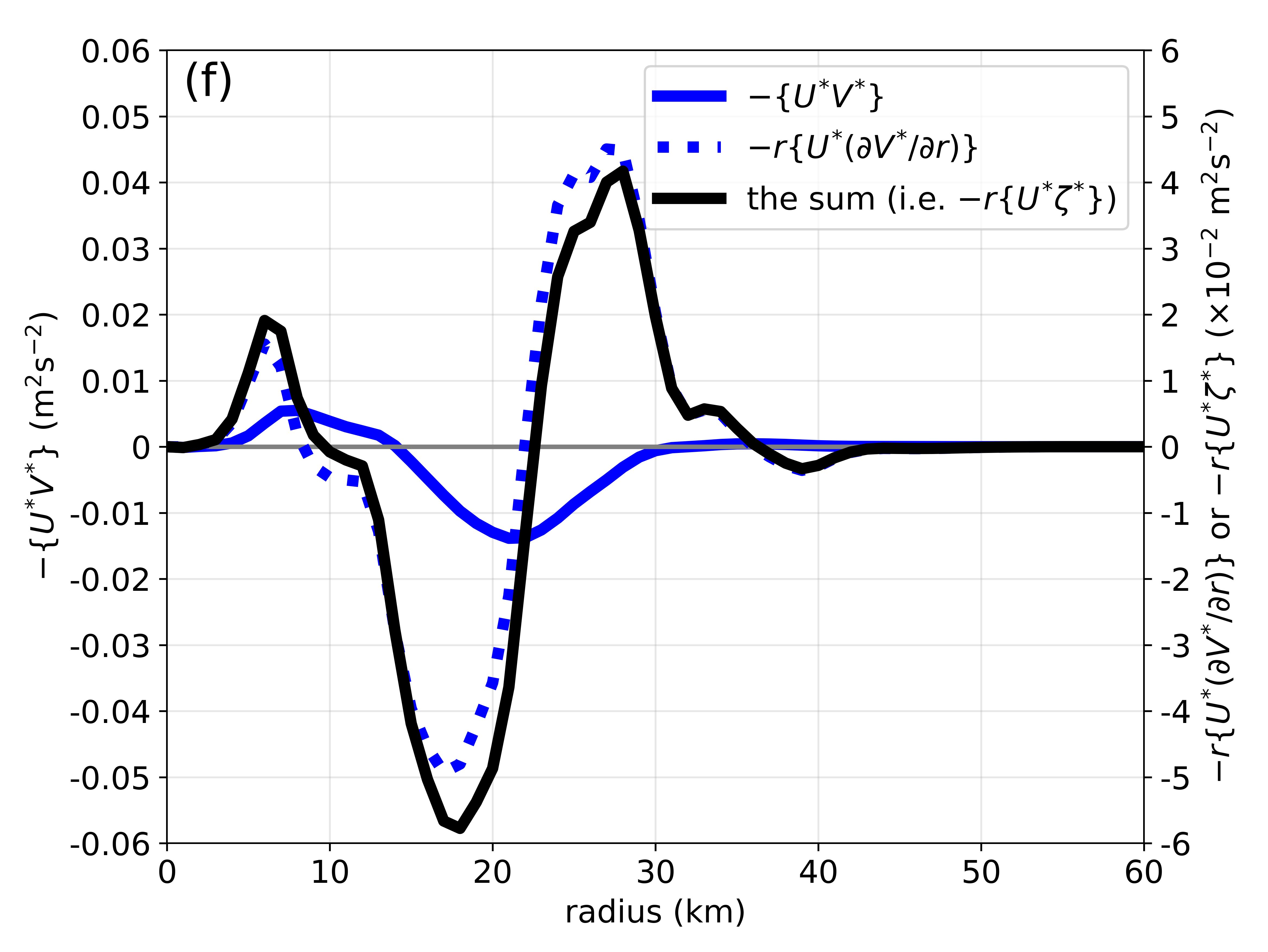
An in-depth analysis of the most unstable mode of a double-eyewall TC-like vortex revealed that the angular momentum flux was pointing outward from the inner eyewall to the outer eyewall. And there was also divergence of the flux over the inner eyewall and convergence of the flux over the outer eyewall [the figure on the left]. This demonstrates that the origin of the intensity changes of the eyewalls is the angular momentum transport from the inner eyewall to the outer eyewall by the eddy processes associated with the type-2 instability. See Lai, Hendricks, Yau, and Menelaou (2021) for more details.
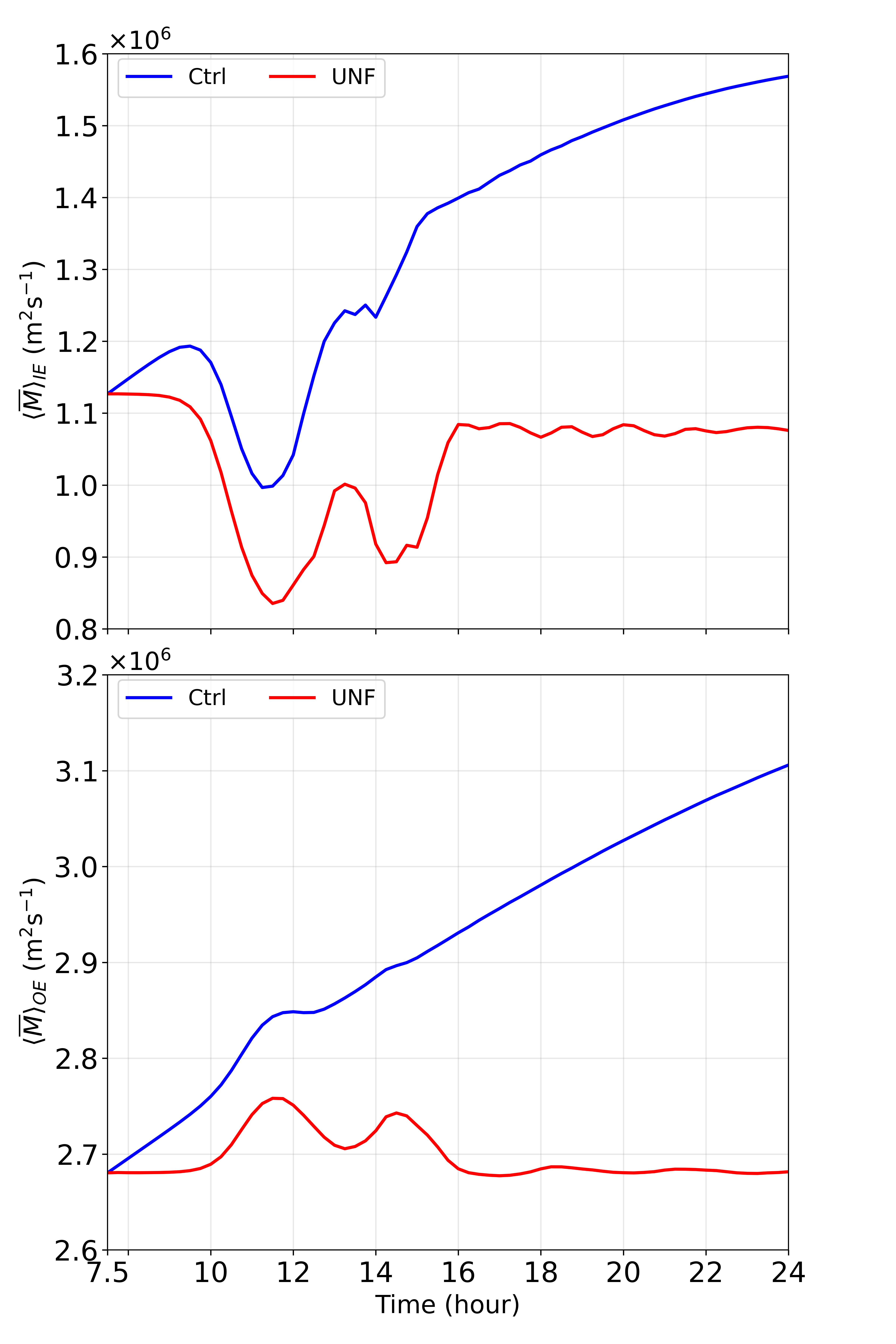
The foregoing analyses focused on the first few hours after the onset of the type-2 instability. The long-term effect of the type-2 instability on ERCs is also explored. Both of the forced and unforced shallow-water experiments exhibit weakening–strengthening cycles (WS cycles) [e.g. the figure on the left] in which the inner eyewalls weaken at first, and then reintensify and weaken again and so on. The trends of the outer eyewalls are reversed. The corresponding rates of change of tangential wind are very substantial during the WS cycles. For example, we see an inner eyewall weakening rate of 21 m/s in 4 hours. See Lai, Hendricks, and Yau (2021) for more details.
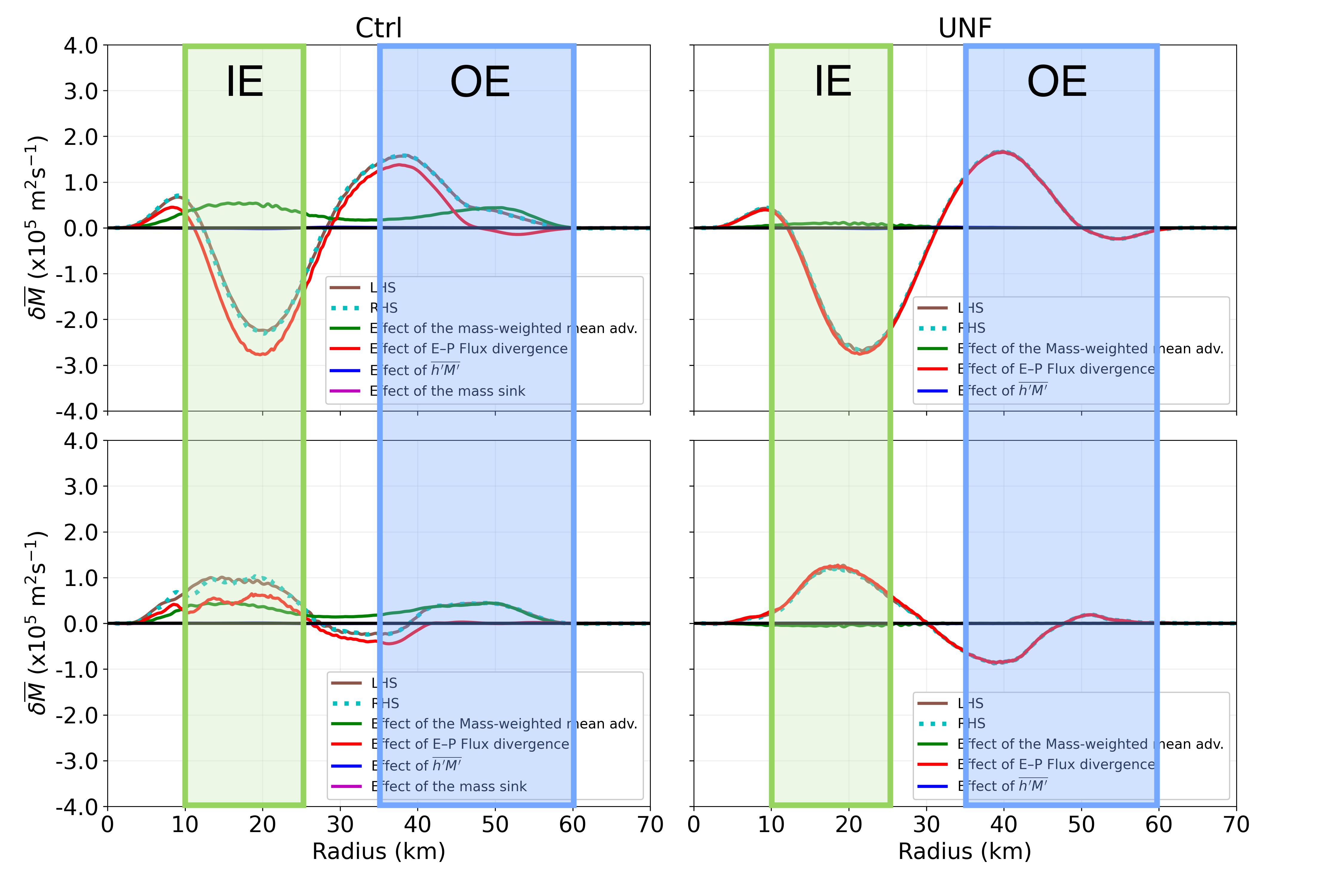
By using the mass-weighted budget of absolute angular momentum, we are able to express the eddy processes associated with the type-2 instability in terms of E–P flux divergence which is the dominant term of the budget. During the weakening phase of the WS cycle, there was E–P flux divergence over the inner eyewall and E–P convergence over the outer eyewall [the top panels of the figure on the left]. The configuration was reversed during the strengthening phase (the bottom panels). These results suggest that the origin of the intensity changes of the two eyewalls during the WS cycle is the angular momentum transport between the two eyewalls. The angular momentum is conserved throughout the eddy processes. See Lai, Hendricks, and Yau (2021) for more details.
Tropical cyclone energy
A TC has multiple forms of energy. The variation of each energy form and the conversion between different forms of energy are important research areas.
Efficiency of latent heat—kinetic energy conversion during intensification
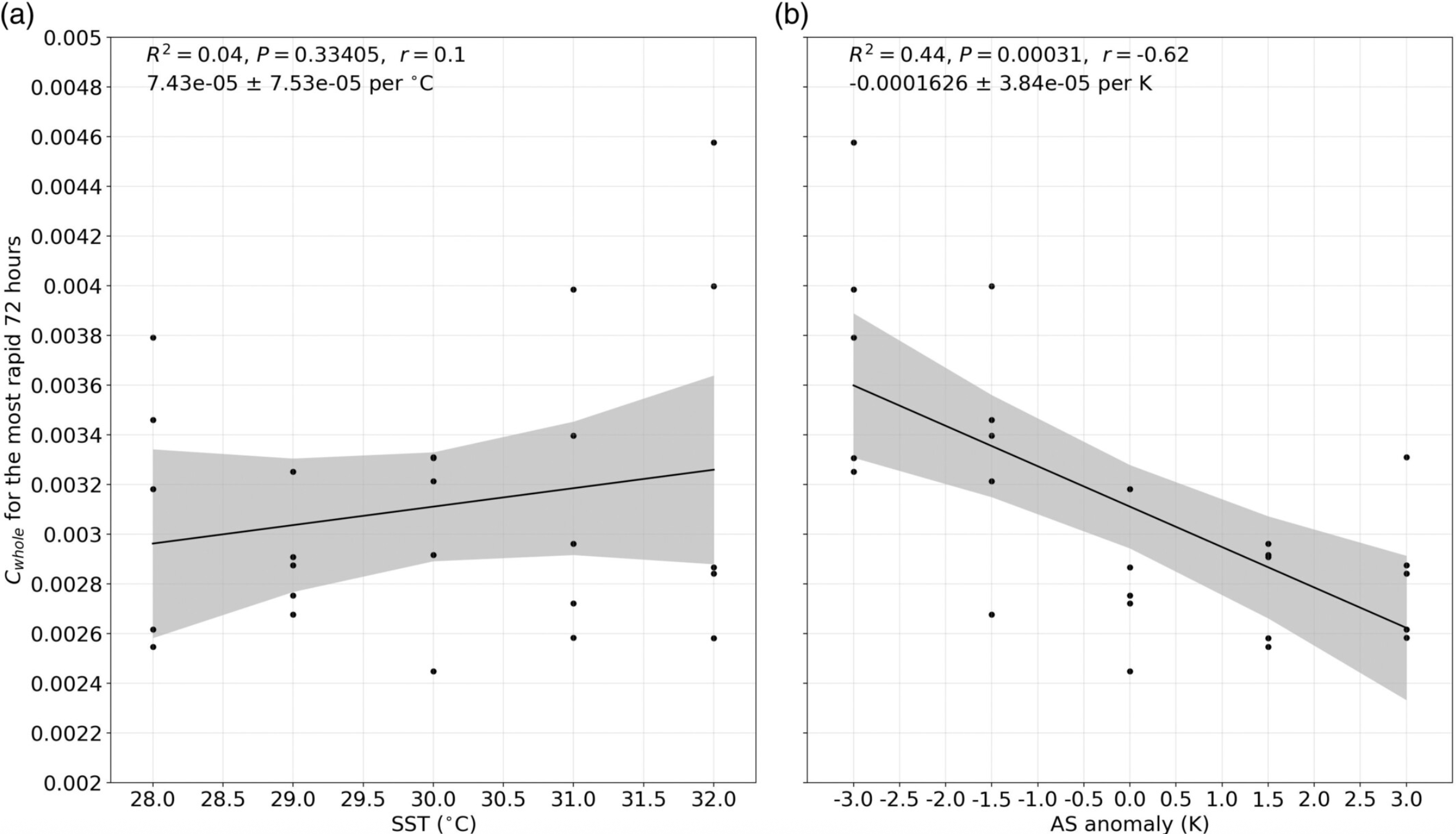
One of the most important types of energy conversion of a TC is the latent heat—kinetic energy conversion. How does the efficiency of this conversion respond to the climate change under which both sea surface temperature (SST) and atmospheric static stability are projected to increase? In a set of idealized simulations, the efficiency does not have a significant relation with the SST. On the other hand, the efficiency decreases with increasing static stability at a rate of about −5% K-1 . It is found that, when static stability increases, the kinetic energy gain declines but the diabatic heating in the eyewall remains unchanged. See Lai and Toumi (2025) for more details.
Subseasonal aspects of tropical cyclones
Due to the huge risk of life and property imposed by TCs, it is of great importance to achieve skillful predictions of activities of TCs as earlier as possible such that the authorities may have enough time to organize hazard preparedness and risk communication with the population being affected. Subseasonal timescale (from 10 days to 1 season) is one of the most important timescales which have a relative lack of skillful TC prediction.
Variability of North American TC landfalls and near-coast phase transitions over the Atlantic coasts
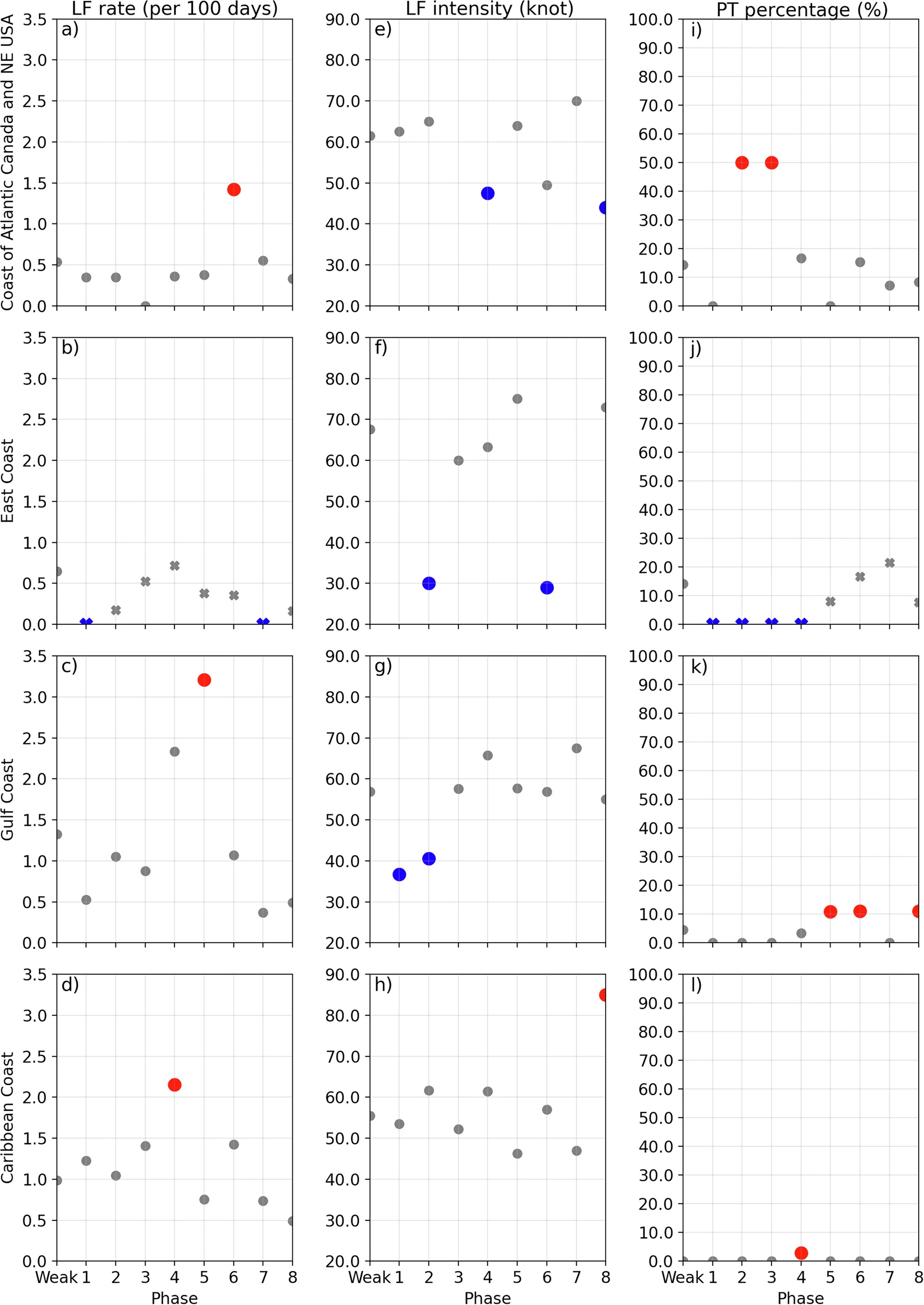
It is shown that the North American Subseasonal Variability (NASV) have substantial modulation of landfalls and near-coast cyclone phase tranistions (PTs) at all Atlantic coasts of the U.S. and Canada. When the anomalies associated with strong northward propagating NASV are located at specific regions, the Atlantic coasts experience significantly different landfall rates, landfall intensities or PT percentages. Thus, our work implies possibilities of improving predictions of landfalls as well as near-coast PTs on both subseasonal and synoptic timescales. Our results also suggest that the convection anomalies over the western tropical Pacific may contribute to NASV. See Lai and Lin (2026) for more details.